Cần Thơ Slums
The city of Cần Thơ, situated in the Mekong Delta, held strategic importance during the Vietnam War due to its economic significance and transportation networks. The Việt Cộng were active in the region, utilizing the waterways to their advantage and staging guerrilla attacks.
Internal name: mcv_slums.bsp
Supported gamemodes: Conquest, Deathmatch, FireFight, Gun Game, Gun Game Deathmatch, Last Man Standing, Last Team Standing, Team Deathmatch
-
 Mapicon
 -
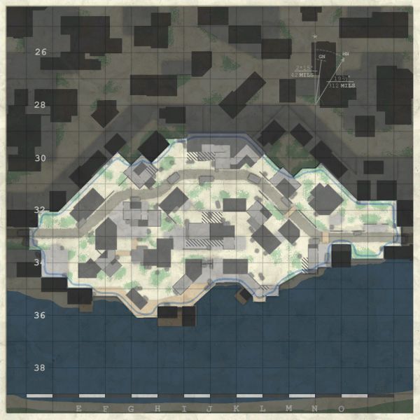 Minimap


History
Cần Thơ Slums is set in one of the most strategically important urban areas of the Mekong Delta during the Vietnam War. Cần Thơ, located on the Hậu Giang (Bassac) River, was the largest city in the delta and a major commercial center in a region that produced much of South Vietnam’s food supply. Because of its size, river access, and role as a transportation hub, the city held both military and economic importance throughout the war.
The wider Mekong Delta was defined by its dense network of rivers, canals, and smaller waterways, which shaped nearly every aspect of the conflict in the region. These waterways allowed the movement of rice, supplies, and people in peacetime, but during the war they also gave Communist forces routes for infiltration, supply traffic, and guerrilla movement. For that reason, allied forces placed great emphasis on river patrols and canal interdiction, and Cần Thơ became a key base for these operations.
As the war expanded, the city grew in importance as a center for South Vietnamese and American military activity in IV Corps. U.S. naval and riverine forces used the Can Tho–Bình Thủy area as a hub for operations against Việt Cộng activity on the surrounding waterways, while the city itself remained vulnerable to attack because of its position deep in the delta. During the Tet Offensive in early 1968, Communist forces struck Cần Thơ along with other major towns in the delta, targeting important government and military sites.
Although the attackers were driven out relatively quickly, the battle showed that even major urban centers in the Mekong Delta were exposed to sudden assault. In that sense, Cần Thơ represented both the economic value and the insecurity of the delta during the war: a crowded river city whose transport links, military presence, and surrounding waterways made it too important for either side to ignore.
Sources
- Encyclopaedia Britannica, Can Tho — https://www.britannica.com/place/Can-Tho
- U.S. Army Center of Military History, Taking the Offensive, October 1966–September 1967 — https://history.army.mil/portals/143/Images/Publications/catalog/76-4.pdf
- Naval History and Heritage Command, May 1966 — https://www.history.navy.mil/research/archives/digital-exhibits-highlights/vietnam-war/highlights-may-1966.html
- Mobile Riverine Force Association, Can Tho U.S. Naval Support Activity 1966-1972 — https://www.mrfa.org/us-navy/us-navy-mobile-riverine-force/u-s-naval-bases-support-activities-vietnam/can-tho-u-s-naval-support-activity-1966-1972/
- Hoang Ngoc Lung, The General Offensives of 1968-69 — https://www.govinfo.gov/content/pkg/GOVPUB-D114-PURL-gpo36269/pdf/GOVPUB-D114-PURL-gpo36269.pdf